Thursday, December 6, 2012


Glacier National Park has a very unique and breathtaking landscape.  This landscape is formed from the many processes that I have previously discussed in this blog.  These forms and processes caused from glacial erosion help create the unique mountain faces, valleys, peaks, and lakes that define Glacier National Park and attract visitors from across the world.  Aside from its unique physical features Glacier National Park also has a very unique climate.  The west side of the park tends to be the warmer and wetter side of the park as it typically receives air currents from the Pacific Ocean and the Eastern side of the park tends to be drier and colder as it typically receives air currents coming off the Great Plains.  This extreme weather is because of its rapid changes in elevation and its location along the Atlantic-Pacific Divide and the Continental Divide.


Over the course of earths history scientists have discovered that the earth moves in and out of glacial periods.  This phenomenon is described as the glacial-interglacial yo-yo effect.  
(A Graph showing the changes in Earths temperatures dating back 450,000 years ago)

A glacial period is described as when the earth is covered in glacial formations and an interglacial period, such as today, is when the earth is covered in less ice/glacial formations.  It is the shift from glacial to interglacial that has created many of the unique landscapes found in Glacier National Park today.  Because these sheets of ice will continue to move and reshape Glacier National Park, the physical features of the park will continue to change over a period of time.  These processes that redefine the physical features of Glacier National Park do not happen overnight though, it is a long process.  Glacier National Park has experienced some of the fastest glacial retreats in the world, hence its rapidly changing features.  A study by NOAA says that because global warming is a natural cycle that can be perpetuated by human activity, specifically carbon monoxide levels, but not caused by human activity this glacial retreat is unstoppable for the next 1,000 years.  This is proposing that the glaciers in GNP will continue to retreat and cause mass erosion creating deeper valleys, sharper peaks, and more variations between rougher and smoother rock faces.  The retreat of these glaciers will also lead to an increased flow of glacial water in the area creating bigger rivers, canyons, and valleys as well as possible erosion caused from floods and mudflows.  
(This Image depicts the predictable erosion and damage that many of the valleys in Glacier National Park could experience)
A study done by NOAA also states that if we humans do start taking intense actions on carbon-monoxide regulations in an attempt to slow down the effects of global warming, these glaciers will not be entirely gone in 1,000 or even 10,000 years.  

Glacier National Park is located along the Lewis Over Thrust Fault.  Because of this many of the changes that will occur in the landscape once most of the glacial ice has retreated will be more related to fault activity then glacial erosion.  In the next 100,000 years the Lewis Overthrust Fault will continue to move older sediments and rock forms over newer sediments of rock.  

This process will force younger rock slabs deeper into the earths core. 

If the rock slabs move far enough they will begin to create volcanic activity and we could see the landscape of what was once Glacier National Park become volcanic.  Glacier covered volcanoes can create a catastrophic environment as volcanic eruptions melt glaciated areas creating destructive mudflows and floods.


Following this volcanic period, an article by the National Geographic declares that in 1,000,000 years much of Canada and the Northern Hemisphere will be covered in large sheets of ice as the next Ice Age should be in its early stages.  In the last 3 million years earths climate has  experienced dozens of ice ages, typically lasting around 41,000 years.  But in the last million and a half years the length of the typical ice age has lasted closer to 100,000 years.  This means that if the length of ice ages continue to grow and grow, in one million years from now what was once known as Glacier National Park will most likely be covered entirely in thick sheets of ice.

It is important to understand that the Earth does cycle in and out of glacial and interglacial periods and the processes discussed in this blog entry are sophisticated guesses of what the climate and landforms of Glacier National Park will look like in extreme conditions.  That being said Glacier National Park will also move in and out of glacial and interglacial periods that will change the landforms seen today, preserve the landforms yet to be created, and then destroy and rebuild new landforms in what was once known as Glacier National Park.


References:


Tuesday, November 13, 2012


The weather climate in Glacier National Park is very unique to many other places.  Glacier National Park does not have one specific climate but is comprised of many microclimates.  This is because of the rapid changes in elevation and its location on the North American Continent.  The park falls along the Atlantic-Pacific Divide and is also separated into eastern and western landscapes by the Rocky Mountains (Continental Divide).

(The Red Line down Montana, where the park is located, is the continental divide separating the park into Eastern and Western sides and influencing the climate change between the two sides.)

Because of this the Western Side of the park tends to be warmer and wetter in relation to the Alaskan Current and the Eastern Side tends to be drier, colder, and windier because of the air current coming from the great plains. 
One of the reasons that the western side of the park receives warmer air currents is because of Air Mass Movement.  The Alaskan current is sending oceanic air masses. Oceanic Air masses tend to be warmer and wetter then continental Air masses.  The Eastern side of the park tends to be colder and dryer because of the continental air mass movement from the great plains just east of the park.  
(It is the mP air current coming from the pacific ocean that creates the wetter and warmer climate on the West side of the park)
This park is composed of many different changes in elevations.  This creates pockets or microclimates based on the different processes the Earth uses to cool and heat different  areas.  It is because of this that the park can experience extreme climate changes.  In fact Glacier National Park holds the world record for the biggest and fastest change in temperature.  In 1916 on the night of January 23-24 the temperature dropped 112 degrees F.  It dropped from 44 F to Negative 56 F.  One of the self regulating processes that lead to such dramatic climate change is related to the processes of global scale circulation.  Global scale circulation sends warmer air upward from lower latitudes to higher latitudes and colder air from higher latitudes to lower latitudes. 
(This topographical map shows the extreme changes in elevation throughout areas of the park.)
Because the Park is made up of many mountains and valleys the latitude of the park is very rarely consistent and the Global scale circulation tends to overlap creating areas of extreme temperatures, both hot and cold depending on the changes in latitude and the season.     

References


Thursday, October 11, 2012

Erosion in Glacier National Park


Glacier National Park is full of many different types of glacial erosion.  This entry will focus on the evidence of scouring, plucking, cirques, horns, and aretes.  All of these forms of erosion help create the unique and beautiful mountains and valleys of Glacier National Park.
       The first form of erosion that I will discuss is scouring.  Scouring is a process in which sediments are dragged or washed across a rock face leaving different sized scratches in the surface of the rock.  Sediments that are not attached to the rock surface are transported across by the glacial water that is melted and flowing down the mountain between the layers of glacial ice and the rock face.  This process can leave long and narrow scratches known as striations.  It can also leave extremely smooth rock surfaces depending on the width of the debris flow.
This is an example of a rock surface that is now smooth from scouring.
This is an example of striations caused from scouring.


The second form of erosion that is very similar to scouring is known as plucking.  Plucking is a process in which glacial water freezes in the cracks on a rock surface.  As the glacial ice begins to move along the side of the mountain the materials, typically rock and soil sediments, are pulled and plucked out of the rock surface.  

When plucking and scouring both occur you find rock features that are smooth on one side, where the scouring occurred, and jagged on the side that the plucking occurred.

The natural movement of glaciers is what leads to glacial erosion.  Plucking and scouring are both a type of glacial erosion but their are also distinctive land features associated with glacial erosion.  Some of these distinctive features are known as cirques, horns, and aretes.  Cirques are the more common physical features of glacial erosion on mountain faces.  Cirques are a bowl shaped depression caused from the downward and outward movement of glaciers. 
This is Iceberg Cirque in Glacier National Park.  Notice how the mountain face is a semicircular depression, very similar to what a half of a cereal bowl would look like.  Its as if someone were to come in and take half of an ice cream scoop out of the mountain.

 Cirques can form other features such as horns and aretes.  Horns are pyramid like peaks created from cirques chiseling away three or more sides of a mountain.  This leaves mountains that could have once been a rounded mountain top looking like a peak with three or more bowl shaped depressions forming a pointed top.  Aretes are formed when two cirques erode a mountain side by side leaving what appears to be a spine like rock figure separating the two cirques.


References
http://www.hartimages.com/photo_9923048.html
http://www.eoearth.org/article/Glacial_landforms?topic=50013

http://libwiki.mcmaster.ca/clip/index.php/Main/RocheMoutonnee


Thursday, September 20, 2012

September 20th, Faults and Weathering


Glacier National Park is full of many different types of unique geographical processes.  Although many of these unique processes are not only found in Glacier National Park, the park provides an observable clarity to the processes that helped form this magnificent landscape.  One of the most studied processes inside the park is referred to as the Lewis overthrust fault.  The Lewis Fault is a low-level thrust fault that has taken   a large slab, approximately 160km long and 6km thick, of Precambrian limestone and thrusted it up and over much younger cretaceous shales.  (http://formontana.net/chief.html

The Lewis overthrust was created due to an uplift in the western part of the rocky mountains that forced the Lewis Thrust Fault to slightly angle upwards.  This uplift was caused by repercussions from transform fault activity along the North American Plate and the Pacific Plate.  This process creates interesting land formations such as chief mountain.  

Chief Mountain is located near the United States Canadian Border and is very unique because of its arrangement of sedimentary rocks.  It is a mountain composed of manly old limestone and quartz that sits on top of a much younger and weaker layer of shales. 


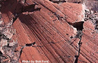
Another process that has helped form some breathtaking mountains in Glacier National Park is known as pressure release weathering.  Many of the mountains in Glacier National Park were once entirely encompassed by glaciers.  These glaciers would then slowly melt due to forces of increased temperature in this part of the world.  Once the glaciers entirely melted the once frozen mountains begin to rebound.  Rebound is a process in which a mountain “unthaws” and attempts to retake its once natural shape.  However in this process rocks slabs crack, break, and fall away from the mountain. 

 This process leaves very distinct forms of rock faces seen in Glacier National Park.

Sources: 
http://mountainbeltway.wordpress.com/2010/08/23/rocks-of-glacier-national-park/
http://nature.nps.gov/geology/parks/glac/
http://formontana.net/chief.html

Thursday, August 30, 2012

Glacier National Park Entry 1


Hi, my name is Riley Cochran.  I am 22 years old and am a junior at the University of Colorado Denver.  I am getting a bachelors degree in psychology with the hopes of having a future career in the field of addiction counseling.  I have lived in Denver, Colorado for almost all of my life.  I absolutely love Colorado and all of the activities that it has to offer.  It is a great mixture of outdoor adventures with a little bit of city life.  I grew up going to various ski resorts in the rocky mountains but spent a majority of my winter weekends in Breckenridge, CO.  My exposure to the Rocky Mountains has made me very enthusiastic about snowboarding, mountain biking, fishing, camping, and many other outdoor activities.  I spent a year and a half of my life going to school in Kalispell, Montana.  While I was living in Kalispell I was able to stumble upon what I believe to be one of the most beautiful places in the United States and possibly the world.  This place is Glacier National Park.


It is a very mountainous and unique national forest located in Northern Montana right along the Canadian border.  
I have decided to blog about this location because of my passion and love for the mountainous terrain that is a lot like our rocky mountains here in Colorado but also very unique. 
  I am very interested to explore the uniqueness of Glacier National Park from a geographical perspective.